Now we turn to the planetary biomes. The proposed approach to their procedural generation, as well as the relief generation, is characterized by two-tier shaping process. A first approximation (global biome shapes) is created at points of the cones’ global lattice, and then true (or local) biome shapes are created at points of the rhombs’ lattice.
In order to not create very long posts again, I will break the narration into two parts. Here will be information about the global biome shapes, the next post will contain
all about true biome shapes, and third everything else. It should also be noted, that there will be a description of the current version of biomes generation, although it will be definitely changed in the future.
A live example of planetary biomes is on the planet Serpento. There are glaciers, tundra, temperate forests, steppe, desert, rainforest, savanna, and equatorial forest.
Global biome shapes
To begin with, the geographical location of biomes on the Earth is determined by a significant number of factors: the latitude and elevation of the location, the air mass movement directions, the proximity of mountain ranges, the ocean currents, and the human activities. In this simple model, which I adopted, I tried to take into account only the latitude and the elevation above the sea level. The influence of other possible factors I convey by random deviations. In general, the planetary biomes disposition can be considered as function bId(lat, h) of latitude and elevation. This function values are biome identifiers.
The domain of bId(lat, h) is a spherical layer over planet surface, with a width equal to the planet’s maximum elevation. This domain is divided into set of possibly overlapping layers; at the beginning they are adjacent to sea level and then they are rising up towards the equator. Each such layer determines the disposition of a particular biome.
Some of these layers, and their corresponding biomes, are considered primary, and others are secondary. Any primary biome is almost always present at any longitude, and a secondary biome may or may not be present within the area of certain primary biomes. For example, on the Serpento, the steppe and the rainforest are defined as primary biomes, and the desert is a secondary biome, that may either be absent altogether or sometimes replaces these primary biomes.
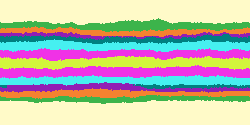
In addition, all layers are divided into elevation sequences (see figure below). This is done in order to convey the fact that the change of biomes with increasing of elevation in different parts of the world occurs in different ways. Researchers of natural biomes subdivide them into dozens of varieties, and the change of biomes with increasing of elevation in the Andes does not quite like as in the Alps.
In my simple model, I can define what sequence of biomes with increasing of elevation will be, depending on the biome at the sea level, which is called base biome. Therefore, biome layers are break into one or several sets depending on the possible base biomes. In the next two figures there are two sequences of biomes accepted for the Serpento. The first is suitable for moist base biomes: equatorial forest -> tropical forest -> temperate forest -> tundra -> ice. The second case is suitable for the arid base biomes: savanna -> steppe -> desert.
 |
 |
Hear are cuts along a longitude. In general, such cuts along different longitudes differ. The biome colors for these diagrams are chosen wisely (randomly).
Also, note that the layers do not rise linearly towards the equator, but according to some power law (power is around 0.5). The central latitude does not have to be the equator and biomes can be asymmetric with respect to it. I suppose to demonstrate this feature on one of the following sample planets.
For generation of biome layers, firstly, we draw a middle curve on sea level strip of each biome layer. I use Fourier synthesized fBm curve because it’s convenient for creating a periodic curve (it also gives a ‘better’ fractal curve as opposed to curve produced with the middle displacement method). Then, depending on each curve relative position, the width of each strip is determined.
Junction areas are made with mixed biomes with special mixing procedure. As a result, biomes will have small random areas beyond the borders of neighboring biomes, its appearance becomes less likely the greater distance from the borders. But more on this in the next post.
The above sea level part of a biome layer reaches a certain elevation, and further it is replaced by another layer with a different biome.
The proposed method leads to the fact that random isolated enclaves of one biome can appear in another biome, and this happens without influence of elevation.
Use in the project
The following diagram shows a schema of base biomes in a rectangular projection applied for the planet Serpento.
What happens if we exclude the ocean points shown bellow.

To be continued..